
Verify Westford Postal Coverage
Only one postal entry is verified in the official material inspected for this Westford ZIP code directory. The record supports a Westford mailing label, but it does not show that the postal area and Town of Westford have identical boundaries. No official source in the research set verified a second local ZIP, a PO Box-only designation, a unique institutional designation, a current station list, or a historic split or realignment.
| ZIP | Areas covered | Postal city | Verification note |
|---|---|---|---|
| 01886 | Westford | Westford | Verified USPS 2025 FAST record |
The table is deliberately narrow. It does not support a broader coverage claim or a claimed historical split. Verify a mailing address through the postal source before using it as the first step in a municipal search.
Westford ZIP Code in USPS FAST
The official USPS FAST label-list record effective August 1, 2025 includes the row 01886 WESTFORD MA 01886. It verifies that postal entry for Westford. USPS ZIP basics describe ZIP lookup as a way to standardize a mailing address. The source does not supply a complete local boundary map or a historic change list.
Use the dated FAST material as a postal verification source, not as a roster of people or parcels.
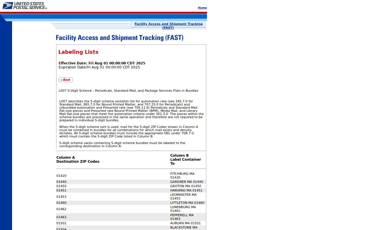
The captured record shows the dated official route behind the verified table entry, which is more precise than repeating an unsupported list of labels.
Westford Postal City and Geographic Town
A postal city is not always the geographic municipality. The MassGIS Municipal Address Standard uses Pine Hill Road as a local example: its postal city is Westford, its ZIP is 01886, and its Address Town is Chelmsford. A mailing label can therefore say Westford while the parcel point belongs geographically to Chelmsford. Record postal city, ZIP, address town, and geographic municipality as separate fields.
Boundary check. A Westford postal label does not prove that a parcel lies in the Town of Westford. Confirm the geographic town before searching municipal records.
That mismatch is a useful local comparison, not a general claim about every address using 01886. It is also why an address should be normalized before it enters an assessor, permit, or deed workflow.
Note: Keep postal city and Address Town in separate fields whenever a record search crosses a municipal boundary.
Westford ZIP Code Form Paths
Westford tools do not treat the postal code in the same way. The state voter-status checker requires a five-digit ZIP along with personal identifying entries and is intended for an individual checking that person's own registration. The polling-place tool accepts a town or ZIP. The observed parcel, Patriot, and permit forms do not offer a ZIP search field. This form-level asymmetry explains why a postal search must hand off to an address or parcel search.
| Official tool | ZIP handling | What the route is for |
|---|---|---|
| Massachusetts voter status | Required: five-digit ZIP, with name and birth-date fields | Self-service registration-status check, not a reverse lookup. |
| Where Do I Vote | Allowed: town/city or ZIP, with street number, street name, and suffix | Address-to-polling-place search. |
| Westford parcel lookup | Absent | Street, house, or parcel-ID search. |
| Patriot assessor search | Absent | Owner, parcel, street, and assessment or sale filters. |
| Westford permit search | Absent | Site-address or parcel-ID permit research. |
The Massachusetts polling-place tool supplies the allowed postal alternative for a street address.
The tool is for election-location information. It does not return a directory of voters or establish who occupies an address.
Move Westford ZIP Code Results
A postal result becomes more useful when it is converted into the field used by Westford's municipal systems. First confirm the mailing address, then use the address rather than the postal code to locate a parcel. This avoids asking a local form for a field it does not accept.
- Start with the complete postal address and verify its ZIP through USPS material.
- Use the polling-place tool when the question is election location, entering the street number, name, suffix, and either town/city or ZIP.
- Normalize the geographic municipality. A postal Westford address can require a Chelmsford municipal search in the Pine Hill Road example.
- Use the appropriate town parcel tool, which searches by street, house, or parcel ID rather than ZIP.
- Save the parcel ID, then compare the assessor result, GIS context, permit history, and Registry reference as needed.
- When the research narrows to one street, use the Westford street directory for the address-to-parcel and recorded-land sequence.
The municipal result should be labeled by its own source date and field names. A postal label, parcel situs, and owner mailing field may all differ.
Westford Parcel Tools Skip ZIP
The town's Parcel/Property Lookup Tools lead to the municipal parcel lookup, Patriot Properties, AxisGIS, permit history, tax maps, and related documents. Their common handoff is a street address or parcel identifier. Patriot offers owner, parcel, street, building type, year built, lot size, value, sale date, and book/page filters, but no ZIP filter in the observed form. AxisGIS searches parcel, address, or owner and adds map layers and abutter context, not postal boundaries.
For a property question, avoid stretching the postal field into an ownership or occupancy claim. The assessor owner field is an assessment record, and map information is not guaranteed current or accurate. Use the parcel ID to move across Westford systems, then check the Registry for the recorded-land chain.
Note: A municipality's parcel search follows local geography, while a postal search standardizes a mailing address for delivery.
Westford Permit Search by Address
The Westford public permit application search also begins with the property, not the postal code. The observed portal uses site address or parcel ID and can expose applications, permit or license type, status, applicant or owner fields, issued permits, inspections, approvals, and fees. Its official pages did not state when online coverage begins.
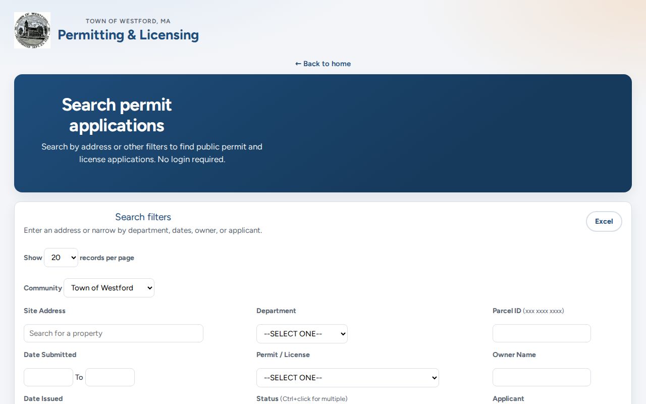
The form demonstrates the local handoff from a verified mailing address to a site-address or parcel query. A permit result concerns an application or property and is not proof of a current resident.
Westford Villages Are Not Postal Labels
Westford's comprehensive plan describes six historic villages: Brookside, Forge Village, Graniteville, Nabnasset, Parker Village, and Center. Those names add historic place context. Forge Village is tied to the Abbot Worsted and Abbot Mill history, Graniteville to machinery, quarrying, and wool, and Nabnasset to lake-cottage history. They are not interchangeable with an official current postal-city field.
No official USPS source in the research set confirms a current postal label for Forge Village or Nabnasset. Use a village name as a historical search term for a map, newspaper, directory, or deed, then retain the source year. Do not turn it into a claimed ZIP label or a present municipal boundary.
Note: Pair a village name with its source year before using it to search an older Westford record.
Westford Postal Labels Need Dates
A current postal label cannot repair a historic address on its own. The town's 2008 address report documents duplicate street names, suffix conflicts, missing or inconsistent numbers, units, unofficial driveways, and records made before streets and addresses were standard index fields. It specifically flags names such as Main, Pine, Coolidge, and Sawmill as records that need a date and source. A modern postal code and number alone cannot safely resolve a nineteenth-century reference.
Keep the historic wording first, then compare it with a dated map, Registry legal description, town parcel, and GIS road layer. The town's 1855 Symmes map gives property names and roads, while the Historic Center material links the Hales 1831, Symmes 1855, Beers 1875, and Walker 1889 maps to historic occupancy evidence. Those maps are orientation aids. They do not convert an old label into a present address or identify a current household.
Westford Postal Bounds and Records
The Westford ZIP code directory is a postal starting point, not a complete resident list or a municipal-boundary map. The verified material supports 01886 and the local Pine Hill Road mismatch example. It does not support a comprehensive split history or claims about unverified PO Box, unique, or station designations. Carry the address through the official route that matches the question, and keep the postal and geographic fields distinct.
Older material may instead use Westford, Chelmsford, a village or mill name, an old road label, or the name of an owner. Preserve that original form and its date before adding a modern postal or parcel cross-reference. This is especially important when a Registry entry depends on a legal description or book/page rather than a delivery address.
- ZIP
- A five-digit postal code used to standardize a mailing address. This research verifies 01886 for Westford in the dated USPS FAST record.
- ZIP+4
- A five-digit ZIP with four additional digits. The source set does not establish a particular Westford ZIP+4 range or boundary.
- PO Box ZIP
- A postal designation associated with PO Box delivery. No Westford PO Box-only ZIP was verified in the official source set.
- Unique ZIP
- A postal designation associated with one large organization or institution. No Westford unique ZIP was verified here.
- Carrier route
- A postal delivery grouping. The research does not identify a Westford carrier-route search field in the town record tools.